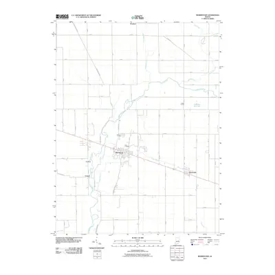
2010 Map of Morristown
USGS Topo · Published 2010About this map
Morristown sits at the heart of this East-Central Indiana landscape, where the grain-farming tradition meets a web of regional watercourses. The Big Blue River snakes through the western portion of the quadrangle, joined by tributaries such as Prairie Branch and Nameless Creek. The settlement pattern reflects nineteenth-century foundations, with Gwynneville and Freeport positioned along the transport corridors that define the local economy. Genealogists and local historians will find several burial grounds documented, including Asbury Cemetery, Davis Cemetery, and Haskett Cemetery, often located near these small crossroads communities. Distinctive topographical features like Hog Back rise above the river valley, while man-made landmarks such as Hamilton Twin Lake punctuate the grid of rural roads. This documentation captures the area as it appeared in the early 21st century, prior to further suburban developments or changes in rural land use.
Find a feature on this map
58 named features on this map. Tap any name to fly to it.
Don’t see what you’re looking for? This feature index may not catch every label — zoom into the map to look around manually.
Map Details
Editions of this 2010 Morristown Map
This is the sole edition of this map. No revisions or reprints were ever made.
Other maps of this area

1952 · Greenfield
USGS Topo · 1:24,000

1952 · Fountaintown
USGS Topo · 1:24,000

1953 · Shelbyville
USGS Topo · 1:24,000

1953 · Cincinnati
USGS Topo · 1:250,000

1956 · Cleveland
USGS Topo · 1:24,000

1956 · Morristown
USGS Topo · 1:24,000

1956 · Rays Crossing
USGS Topo · 1:24,000

1957 · Cincinnati
USGS Topo · 1:250,000
1960 · Manilla
USGS Topo · 1:24,000
1960 · Carthage
USGS Topo · 1:24,000