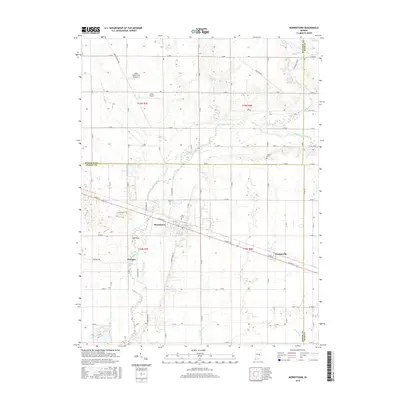
2016 Map of Morristown
USGS Topo · Published 2016About this map
Morristown sits at the heart of this Indiana agricultural landscape, where the east-west corridor of Main St connects it to the neighboring settlement of Gwynneville. The Big Blue River meanders through the western half of the terrain, carving a distinct valley near Freeport and the prominent elevation known as Hog Back. This 2016 survey captures the rural character of the Shelby and Hancock County border, defined by a rectilinear grid of gravel and paved roads like S Morristown Pike and S Binford Rd. Genealogists will find several small burial grounds across the farmland, including Asbury Cem and Haskett Cem. The local aviation history is represented by the Willis Airport and its secondary site. Tributaries such as Sixmile Creek, Prairie Run, and Cotton Run create a dense drainage network that continues to shape the local land use and farm boundaries.
Find a feature on this map
38 named features on this map. Tap any name to fly to it.
Don’t see what you’re looking for? This feature index may not catch every label — zoom into the map to look around manually.
Map Details
Editions of this 2016 Morristown Map
This is the sole edition of this map. No revisions or reprints were ever made.
Other maps of this area

1952 · Greenfield
USGS Topo · 1:24,000

1952 · Fountaintown
USGS Topo · 1:24,000

1953 · Shelbyville
USGS Topo · 1:24,000

1953 · Cincinnati
USGS Topo · 1:250,000

1956 · Cleveland
USGS Topo · 1:24,000

1956 · Morristown
USGS Topo · 1:24,000

1956 · Rays Crossing
USGS Topo · 1:24,000

1957 · Cincinnati
USGS Topo · 1:250,000
1960 · Manilla
USGS Topo · 1:24,000
1960 · Carthage
USGS Topo · 1:24,000