
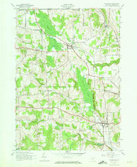
1943 Map of Morrisville
USGS Topo · Published 1960About this map
Morrisville and the surrounding township lands of Smithfield and Eaton appear here during the mid-war years of the early 1940s. The landscape is defined by its dramatic topographic relief, notably where the village of Peterboro sits between the vast wetlands of the Peterboro Swamp and the elevations of Mutton Hill. The region's early rural infrastructure remains highly visible, marked by numerous schoolhouses such as School No 7 and the descriptively named Swamp Sch.
Find a feature on this map
38 named features on this map. Tap any name to fly to it.
Don’t see what you’re looking for? This feature index may not catch every label — zoom into the map to look around manually.
Map Details
Editions of this 1943 Morrisville Map
2 editions found
Other maps of this area

1895 · Chittenango
USGS Topo · 1:62,500

1895 · Oneida
USGS Topo · 1:62,500

1897 · Cazenovia
USGS Topo · 1:62,500

1898 · Oneida
USGS Topo · 1:62,500

1898 · Chittenango
USGS Topo · 1:62,500

1899 · Cazenovia
USGS Topo · 1:62,500

1902 · Chittenango
USGS Topo · 1:62,500

1902 · Morrisville
USGS Topo · 1:62,500

1902 · Oneida
USGS Topo · 1:62,500

1939 · Oneida
USGS Topo · 1:62,500