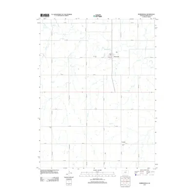
2012 Map of Morrowville
USGS Topo · Published 2012About this map
Morrowville serves as the primary hub in this portion of Washington County, its street grid defined by Elm St and Locust St north of the east-west highway corridor. The surrounding landscape is defined by a dense network of waterways including Mill Creek, Buffalo Creek, and Iowa Creek, which carve through the agricultural sections. For those researching local history, several burial sites are documented across the township, including Morrisville Cem west of town and the Friends Cem near Enosdale in the southeast. The area maintains a strict section-line road system, with routes like Gypsum Rd, Indian Rd, and Liberty Rd providing access to the various creek valleys and the dispersed settlement of Enosdale.
Find a feature on this map
35 named features on this map. Tap any name to fly to it.
Don’t see what you’re looking for? This feature index may not catch every label — zoom into the map to look around manually.
Map Details
Editions of this 2012 Morrowville Map
This is the sole edition of this map. No revisions or reprints were ever made.
Other maps of this area

1893 · Washington
USGS Topo · 1:125,000

1955 · Manhattan
USGS Topo · 1:250,000

1956 · Manhattan
USGS Topo · 1:250,000

1957 · Manhattan
USGS Topo · 1:250,000

1965 · Brantford
USGS Topo · 1:24,000
1966 · Washington NW
USGS Topo · 1:24,000

1966 · Morrowville
USGS Topo · 1:24,000

1966 · Washington
USGS Topo · 1:24,000
1966 · Washington NE
USGS Topo · 1:24,000
1966 · Haddam
USGS Topo · 1:24,000