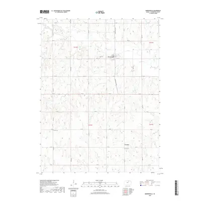
2018 Map of Morrowville
USGS Topo · Published 2018About this map
Morrowville serves as the central hub of this Washington County landscape, where the local street grid including Elm St and Locust St meets the section-line road network. The surrounding prairie is defined by a dense dendritic drainage pattern, with Mill Creek and Buffalo Cr carving through the agricultural terrain. To the south, the small community of Enosdale sits along 14th Rd, reflecting the dispersed settlement patterns typical of the Great Plains.
Find a feature on this map
43 named features on this map. Tap any name to fly to it.
Don’t see what you’re looking for? This feature index may not catch every label — zoom into the map to look around manually.
Map Details
Editions of this 2018 Morrowville Map
This is the sole edition of this map. No revisions or reprints were ever made.
Other maps of this area

1893 · Washington
USGS Topo · 1:125,000

1955 · Manhattan
USGS Topo · 1:250,000

1956 · Manhattan
USGS Topo · 1:250,000

1957 · Manhattan
USGS Topo · 1:250,000

1965 · Brantford
USGS Topo · 1:24,000
1966 · Washington NW
USGS Topo · 1:24,000

1966 · Morrowville
USGS Topo · 1:24,000

1966 · Washington
USGS Topo · 1:24,000
1966 · Washington NE
USGS Topo · 1:24,000
1966 · Haddam
USGS Topo · 1:24,000