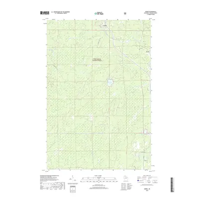
2018 Map of Morse
USGS Topo · Published 2018About this map
Chequamegon National Forest encompasses the majority of this landscape in Ashland County, where the northern Wisconsin terrain is defined by a dense network of river systems and glacial lakes. The Bad River and Moose River serve as primary drainage basins, joined by smaller tributaries like Squaw Cr and Muskeg Cr. Settlement is concentrated near the railroad corridor that links Cayuga in the north to the community of Morse in the east. This area reflects a quiet, modern rural character where land use is split between protected forest and small private holdings. Local history is anchored at the Morse Cem, while the interior remains largely roadless, accessible only by a few named routes such as the Cayuga Connector and Bolden Rd. Distinctive water bodies like Spillerberg Lake and Seagels Lake dot the wetlands, illustrating the boggy, post-glacial hydrology characteristic of the region.
Find a feature on this map
23 named features on this map. Tap any name to fly to it.
Don’t see what you’re looking for? This feature index may not catch every label — zoom into the map to look around manually.
Map Details
Editions of this 2018 Morse Map
This is the sole edition of this map. No revisions or reprints were ever made.
Other maps of this area

1942 · Glidden
USGS Topo · 1:48,000

1942 · Clam Lake
USGS Topo · 1:48,000

1942 · Mellen
USGS Topo · 1:48,000

1942 · Marengo
USGS Topo · 1:48,000

1945 · Marengo
USGS Topo · 1:48,000

1945 · Clam Lake
USGS Topo · 1:48,000

1945 · Glidden
USGS Topo · 1:48,000

1945 · Mellen
USGS Topo · 1:48,000

1953 · Ashland
USGS Topo · 1:250,000
1956 · Mt. Whittlesey
USGS Topo · 1:24,000