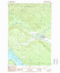
1987 Map of Morton
USGS Topo · Published 1987About this map
The town of Morton serves as a central hub in this late 1980s landscape, situated where the Tilton River meets local infrastructure like Strom Field and a nearby substation. The map reveals a transition from the structured street grid and residential clusters of the town to the managed wilderness of the Snoqualmie National Forest to the north. Resource extraction is evident through numerous borrow pits and a gravel pit scattered across the terrain, supporting the local timber and construction economies of Lewis County.
Find a feature on this map
35 named features on this map. Tap any name to fly to it.
Don’t see what you’re looking for? This feature index may not catch every label — zoom into the map to look around manually.
Map Details
Editions of this 1987 Morton Map
2 editions found
Other maps of this area

1919 · Mount St Helens
USGS Topo · 1:125,000

1937 · Eatonville
USGS Topo · 1:125,000

1953 · Hoquiam
USGS Topo · 1:250,000

1953 · Elk Rock
USGS Topo · 1:62,500

1956 · Mineral
USGS Topo · 1:62,500

1957 · Hoquiam
USGS Topo · 1:250,000

1957 · Morton
USGS Topo · 1:62,500

1957 · Spirit Lake
USGS Topo · 1:62,500

1958 · Hoquiam
USGS Topo · 1:250,000

1962 · Hoquiam
USGS Topo · 1:250,000