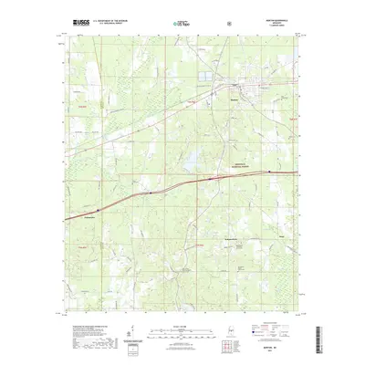
2021 Map of Morton
USGS Topo · Published 2021About this map
The town of Morton serves as a central hub on this landscape where the Bienville National Forest meets the agricultural lands of Scott and Rankin counties. The terrain is defined by a series of winding waterways including Pelahatchie Creek, Line Creek, and the Strong River as they move through timbered blocks and open fields. For genealogists, the map is particularly rich in cemetery data, documenting small rural congregational sites such as the Independence Methodist Church Cem and the Mount Olive Primitive Baptist Church Cem. These church and burial locations, along with small crossroads like Independence and Stage, preserve the footprint of rural community life in central Mississippi. The transport network reflects both old rural routes like Lott Rd and modern thoroughfares, illustrating how the region has maintained its small-town character while remaining connected to larger corridors.
Find a feature on this map
83 named features on this map. Tap any name to fly to it.
Don’t see what you’re looking for? This feature index may not catch every label — zoom into the map to look around manually.
Map Details
Editions of this 2021 Morton Map
This is the sole edition of this map. No revisions or reprints were ever made.
Other maps of this area

1922 · Morton
USGS Topo · 1:48,000

1922 · Pelahatchee
USGS Topo · 1:48,000

1924 · Pelahatchee
USGS Topo · 1:62,500

1924 · Morton
USGS Topo · 1:62,500

1950 · Pelahatchie
USGS Topo · 1:62,500

1951 · Morton
USGS Topo · 1:62,500

1952 · Pelahatchie
USGS Topo · 1:62,500

1953 · Meridian
USGS Topo · 1:250,000

1957 · Meridian
USGS Topo · 1:250,000

1965 · Meridian
USGS Topo · 1:250,000