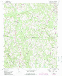
1971 Map of Morven West
USGS Topo · Published 1988About this map
Morven stands as the primary center of activity in this 1971 survey of the North Carolina-South Carolina borderlands. The landscape is characterized by a dense network of creek branches and agricultural field patterns, with significant revisions added in the 1980s that reveal changes in woodland cover and infrastructure over a fifteen-year period. This edition, based on 1969 aerial photography and later field-checked, provides a clear view of the rural development spanning the Anson Co and Chesterfield Co line. Local historians can trace the transition from traditional farm layouts to more modern land use patterns, as evidenced by the updated purple markings on the sheet.
Find a feature on this map
1 named feature on this map. Tap any name to fly to it.
Don’t see what you’re looking for? This feature index may not catch every label — zoom into the map to look around manually.
Map Details
Editions of this 1971 Morven West Map
2 editions found
Other maps of this area

1941 · Spartanburg
USGS Topo · 1:250,000

1942 · Rockingham
USGS Topo · 1:125,000

1953 · Florence
USGS Topo · 1:250,000

1953 · Spartanburg
USGS Topo · 1:250,000

1954 · Florence
USGS Topo · 1:250,000
1956 · Lilesville
USGS Topo · 1:24,000

1956 · Wadesboro
USGS Topo · 1:24,000

1960 · Spartanburg
USGS Topo · 1:250,000

1963 · Spartanburg
USGS Topo · 1:250,000

1964 · Spartanburg
USGS Topo · 1:250,000