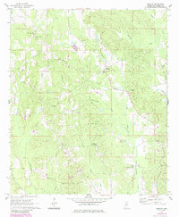
1962 Map of Moscow
USGS Topo · Published 1985About this map
Kemper County’s rolling landscape is defined by the headwaters of the Chickasawhay Creek and its many tributaries, such as Tullachula Creek and Pawticfaw Creek. The settlement of Moscow serves as a local hub, anchored by the West Kemper Ch and nearby Mt Zion Ch. This 1962 field-checked record captures the area as a network of small family farms and timberlands before more modern developments altered the rural road patterns. The mapping shows an extensive list of community centers that were vital to the era, including the Little Rock Sch and numerous country churches like Shiloh Ch and Big Oak Ch. Genealogists will find particular value in the meticulous marking of family-named burial grounds like McDonald Cem, Talbert Cem, and the Linwood Cem. In the southern portion of the quadrangle, the community of Damascus and the Mt Pleasant Ch cluster near the banks of Penders Creek, illustrating how closely these early Mississippi settlements followed the local drainage systems.
Find a feature on this map
36 named features on this map. Tap any name to fly to it.
Don’t see what you’re looking for? This feature index may not catch every label — zoom into the map to look around manually.
Map Details
Editions of this 1962 Moscow Map
4 editions found
Other maps of this area

1953 · Meridian
USGS Topo · 1:250,000

1957 · Meridian
USGS Topo · 1:250,000

1962 · House
USGS Topo · 1:24,000

1962 · Lynville
USGS Topo · 1:24,000

1962 · Daleville
USGS Topo · 1:24,000

1962 · Owl Creek
USGS Topo · 1:24,000

1962 · Lauderdale NW
USGS Topo · 1:24,000

1962 · Center Hill
USGS Topo · 1:24,000

1962 · Post
USGS Topo · 1:24,000

1962 · Moscow
USGS Topo · 1:24,000