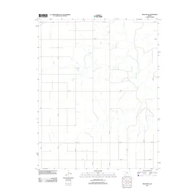
2012 Map of Moscow SE
USGS Topo · Published 2012About this map
The Cimarron River winds through this section of Seward County, carving a distinct path across a landscape defined by an orderly grid of rural transport routes. The river’s drainage patterns create the primary topographic variation in an area otherwise dominated by agriculture and utility. For those researching local burial sites or family heritage in the region, the O'Dea Cem is a prominent landmark located in the northwestern portion of the map near Road 23. This 2012 survey illustrates the modern configuration of the county road system, including key connectors like Road V and 10mi Rd, which facilitate movement between isolated homesteads and the vast plains of Southwest Kansas.
Find a feature on this map
17 named features on this map. Tap any name to fly to it.
Don’t see what you’re looking for? This feature index may not catch every label — zoom into the map to look around manually.
Map Details
Editions of this 2012 Moscow SE Map
This is the sole edition of this map. No revisions or reprints were ever made.
Other maps of this area

1944 · Moscow
USGS Topo · 1:62,500

1945 · Moscow
USGS Topo · 1:62,500

1955 · Dodge City
USGS Topo · 1:250,000

1958 · Dodge City
USGS Topo · 1:250,000

1959 · Dodge City
USGS Topo · 1:250,000

1968 · Sublette SW
USGS Topo · 1:24,000
1968 · Satanta
USGS Topo · 1:24,000

1968 · Liberal NW
USGS Topo · 1:24,000
1974 · Moscow SE
USGS Topo · 1:24,000
1974 · Moscow
USGS Topo · 1:24,000