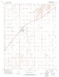
1974 Map of Moscow
USGS Topo · Published 1976About this map
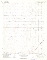
Moscow stands as the central hub of this Kansas plains landscape, deeply defined by the energy and transportation infrastructure of the mid-1970s. The town's diagonal orientation is dictated by the Atchison Topeka and Santa Fe railroad, which cuts through the High Plains terrain. This era of development is marked by a proliferation of Gas Wells scattered across the grid-patterned sections, signaling the importance of the local natural gas fields. Just outside the main settlement, the Moscow Cem provides a point of interest for genealogists, while a nearby Landing Strip and multiple Pipelines illustrate the logistical requirements of this industrial and agricultural region. The map captures a moment when traditional rail transit and modern energy extraction coexisted as the primary economic drivers of Stevens County.
Find a feature on this map
8 named features on this map. Tap any name to fly to it.
Don’t see what you’re looking for? This feature index may not catch every label — zoom into the map to look around manually.
Map Details
Editions of this 1974 Moscow Map
This is the sole edition of this map. No revisions or reprints were ever made.
Other maps of this area

1944 · Moscow
USGS Topo · 1:62,500

1945 · Moscow
USGS Topo · 1:62,500

1955 · Dodge City
USGS Topo · 1:250,000

1958 · Dodge City
USGS Topo · 1:250,000

1959 · Dodge City
USGS Topo · 1:250,000

1974 · Hugoton
USGS Topo · 1:24,000
1974 · Wagon Bed Spring
USGS Topo · 1:24,000
1974 · Moscow SE
USGS Topo · 1:24,000
1974 · Woods
USGS Topo · 1:24,000
1974 · Wagon Bed Spring SE
USGS Topo · 1:24,000