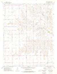
1974 Map of Moscow SE
USGS Topo · Published 1976About this map
The Cimarron River carves a winding path across this High Plains landscape, marking a distinct break in the otherwise orderly grid of the mid-1970s. This territory, spanning the border of Stevens and Seward counties, is defined by its energy infrastructure and agricultural layout. Extensive pipelines and numerous gas wells crisscross the terrain, supported by industrial features like the Compressor Station in the north. Local history is anchored by the Golden Plains Cem and O'Dea Cem, which serve as quiet landmarks among the fields. The map also captures several Gravel Pit operations near the riverbanks, reflecting the local extraction economy of the era. The detailed inclusion of fence and field lines provides an exceptionally clear view of land use and property boundaries during this period of Kansas history.
Find a feature on this map
12 named features on this map. Tap any name to fly to it.
Don’t see what you’re looking for? This feature index may not catch every label — zoom into the map to look around manually.
Map Details
Editions of this 1974 Moscow SE Map
This is the sole edition of this map. No revisions or reprints were ever made.
Other maps of this area

1944 · Moscow
USGS Topo · 1:62,500

1945 · Moscow
USGS Topo · 1:62,500

1955 · Dodge City
USGS Topo · 1:250,000

1958 · Dodge City
USGS Topo · 1:250,000

1959 · Dodge City
USGS Topo · 1:250,000

1968 · Sublette SW
USGS Topo · 1:24,000
1968 · Satanta
USGS Topo · 1:24,000

1968 · Liberal NW
USGS Topo · 1:24,000
1974 · Moscow
USGS Topo · 1:24,000
1974 · Woods
USGS Topo · 1:24,000