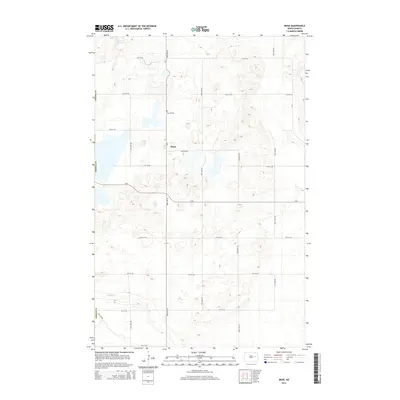
2014 Map of Mose
USGS Topo · Published 2014About this map
Mose stands as the central point of interest in this section of Griggs County, where the prairie landscape is defined by a rigid section-line road grid. The settlement is situated at the intersection of 98th Ave NE and Cr-8, reflecting a classic Great Plains agricultural distribution pattern. To the north, the Naroen Cemetery provides a specific site of interest for genealogists tracing early families in the region. The topography is marked by numerous small depressions and water bodies, most notably Hoot-E-Too Lake in the northwest and the winding course of Baldhill Creek as it cuts through the southwestern corner. This 2014 survey documents the enduring layout of rural township roads, from 6th St NE up to 14th St NE, which continue to facilitate the transport of local agricultural yields.
Find a feature on this map
22 named features on this map. Tap any name to fly to it.
Don’t see what you’re looking for? This feature index may not catch every label — zoom into the map to look around manually.
Map Details
Editions of this 2014 Mose Map
This is the sole edition of this map. No revisions or reprints were ever made.
Other maps of this area

1900 · Pingree
USGS Topo · 1:125,000

1951 · Glenfield
USGS Topo · 1:24,000

1952 · New Rockford
USGS Topo · 1:250,000

1956 · New Rockford
USGS Topo · 1:250,000

1961 · McHenry
USGS Topo · 1:24,000

1961 · Binford
USGS Topo · 1:24,000

1961 · Sutton
USGS Topo · 1:24,000

1961 · Johnson Lake
USGS Topo · 1:24,000

1961 · Binford NE
USGS Topo · 1:24,000
1961 · Binford NW
USGS Topo · 1:24,000