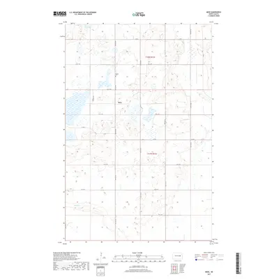
2017 Map of Mose
USGS Topo · Published 2017About this map
Mose sits at the heart of this North Dakota landscape, surrounded by a systematic grid of section lines and gravel roads characteristic of the Great Plains. The topography is defined by the glacial depressions of the Prairie Pothole Region, with Hoot-E-Too Lake in the northwest and various unnamed wetlands scattered across t148n r61w and t147n r61w. For local historians and genealogists, the Naroen Cem in the northern half of the quadrangle serves as a significant site for family research. In the southern reaches, the drainage of Baldhill Cr cuts through the terrain, providing a natural contrast to the rigid geometry of the county road system, including Co RD 2 and Co RD 8, which link the isolated farmsteads of Griggs County.
Find a feature on this map
14 named features on this map. Tap any name to fly to it.
Don’t see what you’re looking for? This feature index may not catch every label — zoom into the map to look around manually.
Map Details
Editions of this 2017 Mose Map
This is the sole edition of this map. No revisions or reprints were ever made.
Other maps of this area

1900 · Pingree
USGS Topo · 1:125,000

1951 · Glenfield
USGS Topo · 1:24,000

1952 · New Rockford
USGS Topo · 1:250,000

1956 · New Rockford
USGS Topo · 1:250,000

1961 · McHenry
USGS Topo · 1:24,000

1961 · Binford
USGS Topo · 1:24,000

1961 · Sutton
USGS Topo · 1:24,000

1961 · Johnson Lake
USGS Topo · 1:24,000

1961 · Binford NE
USGS Topo · 1:24,000
1961 · Binford NW
USGS Topo · 1:24,000