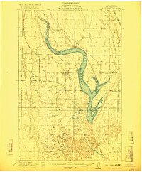
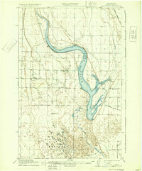
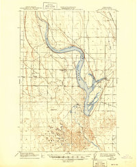
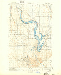
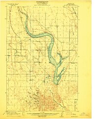
1912 Map of Moses Lake
USGS Topo · Published 1922About this map
Moses Lake dominates this central Washington landscape as it appeared in the early twentieth century, defined by its distinctive branching arms like Pelican Horn and Parker Horn. The terrain transitions from the open stretches of Pleasant Valley in the west to the intricate geomorphology of The Potholes in the south. This survey captures a moment of early development in Grant County, where the settlement of Mae and the village of Moses Lake serve as small hubs for the surrounding prairie.
Find a feature on this map
17 named features on this map. Tap any name to fly to it.
Don’t see what you’re looking for? This feature index may not catch every label — zoom into the map to look around manually.
Map Details
Editions of this 1912 Moses Lake Map
6 editions found

Other maps of this area
1910 · Winchester
USGS Topo · 1:62,500

1911 · Red Rock
USGS Topo · 1:62,500
1912 · Moses Lake
USGS Topo · 1:62,500

1923 · Corfu
USGS Topo · 1:62,500

1923 · Wheeler
USGS Topo · 1:62,500

1924 · Othello
USGS Topo · 1:62,500

1925 · Wheeler
USGS Topo · 1:62,500

1950 · Smyrna
USGS Topo · 1:62,500

1951 · Smyrna
USGS Topo · 1:62,500

1951 · Corfu
USGS Topo · 1:62,500