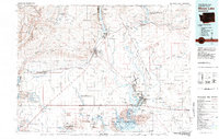
1982 Map of Moses Lake
USGS Topo · Published 1983About this map
The dramatic geography of the Columbia Basin is captured in detail during the early 1980s, showcasing the intricate relationship between the region's volcanic past and its modern irrigation infrastructure. The landscape is dominated by the massive Potholes Reservoir and the winding Moses Lake, features that define the water-starved terrain of the Grand Coulee. The presence of the Main Canal and West Canal networks illustrates the scale of the Columbia Basin Project, which transformed this arid plateau into a productive agricultural hub centered around towns like Ephrata and Quincy.
Find a feature on this map
67 named features on this map. Tap any name to fly to it.
Don’t see what you’re looking for? This feature index may not catch every label — zoom into the map to look around manually.
Map Details
Editions of this 1982 Moses Lake Map
2 editions found
Other maps of this area

1901 · Chelan
USGS Topo · 1:125,000

1909 · Quincy
USGS Topo · 1:62,500

1910 · Quincy
USGS Topo · 1:62,500

1910 · Winchester
USGS Topo · 1:62,500

1911 · Red Rock
USGS Topo · 1:62,500

1912 · Moses Lake
USGS Topo · 1:62,500

1912 · Beverly
USGS Topo · 1:62,500

1912 · Malaga
USGS Topo · 1:48,000

1914 · Malaga
USGS Topo · 1:62,500

1916 · Connell
USGS Topo · 1:125,000