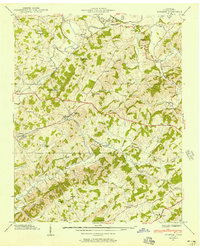
1939 Map of Mosheim
USGS Topo · Published 1957About this map
The Southern railroad line anchors the development of Greene County as it cuts across the landscape, connecting the village of Mosheim and the settlement at Midway. This agricultural and rural industrial hub relies heavily on the winding courses of Lick Creek and Little Chucky Creek, which provided the necessary water power for local operations like Hull Mill. The interior is dotted with a dense network of nineteenth-century social institutions, including numerous rural schools such as Gethsemane Sch and New Bethel Sch, alongside country churches like Big Spring Ch and Hartman Ch. The presence of the Andrew Johnson Highway indicates the area's transition into the early automobile era, while older family and community markers like Susong Cem remain central to the local geography. The map provides a detailed view of the Greene County topography just before the mid-century period, capturing the intersection of rail, road, and river life.
Find a feature on this map
39 named features on this map. Tap any name to fly to it.
Don’t see what you’re looking for? This feature index may not catch every label — zoom into the map to look around manually.
Map Details
Editions of this 1939 Mosheim Map
3 editions found
Other maps of this area

1883 · Morristown
USGS Topo · 1:125,000

1892 · Greeneville
USGS Topo · 1:125,000

1893 · Morristown
USGS Topo · 1:125,000

1895 · Morristown
USGS Topo · 1:125,000

1896 · Greeneville
USGS Topo · 1:125,000

1904 · Greeneville
USGS Topo · 1:125,000

1935 · Surgoinsville
USGS Topo · 1:48,000

1935 · Baileyton
USGS Topo · 1:24,000

1935 · Rogersville
USGS Topo · 1:48,000

1935 · Parrottsville
USGS Topo · 1:24,000