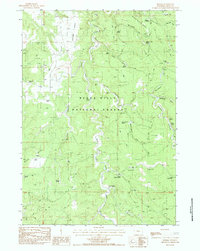
1984 Map of Moskee
USGS Topo · Published 1984About this map
Black Hills National Forest land dominates this 1980s landscape, where a network of water sources and high ridges defines the local geography. The central drainage of Moskee Creek flows through the heart of the area, flanked by prominent features like Grand Canyon and Schoolhouse Gulch. Significant topographic landmarks such as Black Buttes and the Williams-Sunrise Divide provide natural boundaries across the terrain, while numerous springs—including Lehner Spring, Dain Spring, and Katan Spring—point to the essential water management of the region.
Find a feature on this map
35 named features on this map. Tap any name to fly to it.
Don’t see what you’re looking for? This feature index may not catch every label — zoom into the map to look around manually.
Map Details
Editions of this 1984 Moskee Map
This is the sole edition of this map. No revisions or reprints were ever made.
Other maps of this area

1898 · Sundance
USGS Topo · 1:125,000

1902 · Sundance
USGS Topo · 1:125,000

1954 · Gillette
USGS Topo · 1:250,000

1955 · Gillette
USGS Topo · 1:250,000

1958 · Gillette
USGS Topo · 1:250,000
1958 · Four Corners
USGS Topo · 1:62,500
1958 · Inyan Kara Mountain
USGS Topo · 1:62,500

1958 · Tinton
USGS Topo · 1:62,500

1958 · Sundance
USGS Topo · 1:62,500

1962 · Gillette
USGS Topo · 1:250,000