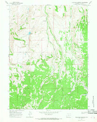
1965 Map of Moslander Reservoir
USGS Topo · Published 1968About this map
Moslander Ridge and the prominent Mumford Ridge define the high country of this Uinta County landscape during the mid-1960s. The area is characterized by a network of seasonal water sources and livestock movement corridors, most notably the Blacks Fork Sheep Trail which cuts across the western slopes. Water management is central to the land's utility here, evidenced by the Moslander Reservoir, Vacher Reservoir, and the engineered Wash Supply Ditch. In this era, the terrain is shaped by sheep ranching and resource management, with named features like Twomile Hollow and Seventeen Spring serving as vital landmarks for navigators and ranchers alike. The dense cluster of springs, including Cold Springs and the sheltered Twentyone Grove, highlights the critical importance of reliable water in the high Wyoming rangeland.
Find a feature on this map
25 named features on this map. Tap any name to fly to it.
Don’t see what you’re looking for? This feature index may not catch every label — zoom into the map to look around manually.
Map Details
Editions of this 1965 Moslander Reservoir Map
2 editions found
Other maps of this area

1885 · Uinta
USGS Topo · 1:250,000

1901 · Hayden Peak
USGS Topo · 1:125,000

1903 · Hayden Peak
USGS Topo · 1:125,000

1954 · Salt Lake City
USGS Topo · 1:250,000

1954 · Ogden
USGS Topo · 1:250,000

1958 · Ogden
USGS Topo · 1:250,000

1958 · Salt Lake City
USGS Topo · 1:250,000

1960 · Ogden
USGS Topo · 1:250,000

1960 · Salt Lake City
USGS Topo · 1:250,000

1965 · Sulphur Creek Reservoir
USGS Topo · 1:24,000