
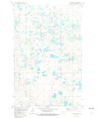
1949 Map of Mosquito Butte
USGS Topo · Published 1949About this map
Spencer and Crowfoot townships anchor this prairie landscape as it appeared in the late 1940s, a region defined by scattered wetlands and remote schoolhouses. The topography is dominated by glacial depressions such as Christensen Slough and Lagorin Slough, while Mosquito Butte serves as a prominent local landmark. This era reveals a rural infrastructure built around community centers like Buck Sch, School No 2, and School No 3, reflecting the density of farmstead populations before the consolidation of mid-century school districts. Religious life is marked by Our Savior Ch and Bethlehem Ch, which stand as focal points for the surrounding families. The map also delineates the meeting point of three counties — Burke, Ward, and Mountrail — providing a clear record of the political and physical boundaries shaping this North Dakota agricultural corridor.
Find a feature on this map
12 named features on this map. Tap any name to fly to it.
Don’t see what you’re looking for? This feature index may not catch every label — zoom into the map to look around manually.
Map Details
Editions of this 1949 Mosquito Butte Map
This is the sole edition of this map. No revisions or reprints were ever made.
Other maps of this area

1948 · Kenmare
USGS Topo · 1:24,000

1948 · Vanville NE
USGS Topo · 1:24,000

1949 · Niobe
USGS Topo · 1:24,000

1949 · Coulee
USGS Topo · 1:24,000

1950 · Vanville NE
USGS Topo · 1:24,000

1950 · Kenmare
USGS Topo · 1:62,500

1953 · Williston
USGS Topo · 1:250,000

1957 · Williston
USGS Topo · 1:250,000

1978 · Westby Lake
USGS Topo · 1:24,000
1981 · Palermo NE
USGS Topo · 1:24,000