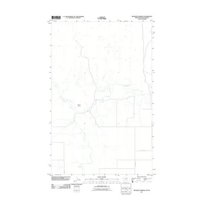
2011 Map of Mosquito Springs
USGS Topo · Published 2011About this map
Mosquito Springs provides a critical water source in this arid stretch of Blaine County along the Montana-Saskatchewan border. The landscape is defined by the drainage patterns of Woody Island Creek, which meanders across the northern and central sections of the quadrangle. Significant topographical relief is found at Murray Coulee, where the terrain drops into the drainage system. The human imprint on this borderland is primarily represented by a sparse network of section roads, including Jenks Rd and Sod Buster Rd, which facilitate movement between scattered agricultural holdings. These roads, along with Bramsom Rd, follow the rigid township and range grid, illustrating the systematic division of land in the rural West.
Find a feature on this map
6 named features on this map. Tap any name to fly to it.
Don’t see what you’re looking for? This feature index may not catch every label — zoom into the map to look around manually.
Map Details
Editions of this 2011 Mosquito Springs Map
This is the sole edition of this map. No revisions or reprints were ever made.
Other maps of this area

1913 · Cherry Ridge
USGS Topo · 1:125,000

1920 · Avery
USGS Topo · 1:125,000

1953 · Havre
USGS Topo · 1:250,000

1957 · Havre
USGS Topo · 1:250,000

1958 · Havre
USGS Topo · 1:250,000

1984 · Hogeland SE
USGS Topo · 1:24,000

1984 · Turner
USGS Topo · 1:24,000
1984 · Turner NW
USGS Topo · 1:24,000
1984 · Hogeland
USGS Topo · 1:24,000
1984 · Hogeland NW
USGS Topo · 1:24,000