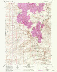
1959 Map of Moss Agate Reservoir
USGS Topo · Published 1985About this map
The Medicine Bow River winds through this high-plains landscape, where the legacy of early ranching and geological interest is clearly etched into the terrain. Names like the Walker Homestead and the Old Bennett Place point toward a history of homesteading and early settlement along the river's drainage. The map highlights a sprawling Petrified Forest Area to the east of Sand Creek, indicating a region rich in paleontological significance that stands in contrast to the functional water-management structures like Moss Agate Reservoir and Howard Reservoir. A remote Landing Field near the northern border suggests the logistical importance of aerial access in this sparsely populated portion of Carbon County. Revisions made in the mid-1980s reflect changes in the landscape several decades after the original mid-century survey, providing a point of comparison for the evolution of local land use.
Find a feature on this map
14 named features on this map. Tap any name to fly to it.
Don’t see what you’re looking for? This feature index may not catch every label — zoom into the map to look around manually.
Map Details
Editions of this 1959 Moss Agate Reservoir Map
2 editions found
Other maps of this area

1955 · Casper
USGS Topo · 1:250,000

1958 · Casper
USGS Topo · 1:250,000

1959 · Moss Agate Reservoir
USGS Topo · 1:24,000

1959 · Squaw Spring
USGS Topo · 1:24,000

1959 · Chalk Hills
USGS Topo · 1:24,000

1959 · Bates Creek Reservoir
USGS Topo · 1:24,000

1960 · Mud Springs
USGS Topo · 1:24,000

1960 · Measel Spring Reservoir
USGS Topo · 1:24,000
1961 · Big Charlie Lakes
USGS Topo · 1:24,000
1961 · Cameron Creek
USGS Topo · 1:24,000