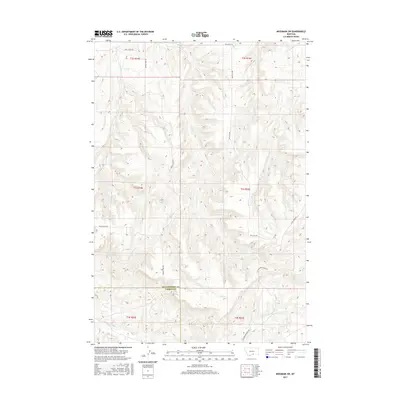
2017 Map of Mossmain SW
USGS Topo · Published 2017About this map
The county line between Yellowstone Co and Carbon Co divides the landscape where the northern foothills of the Pryor Mountains meet the drainages of the Yellowstone River valley. This high-plains terrain is defined by a series of parallel watercourses including Spring Creek, Davis Creek, and Duck Creek, which flow northward through sections of deep relief. The map reveals a remote pastoral and industrial network, with routes like Moser Dome Rd and Price Hill Rd providing access to the high ground between the draws. In the southern portion of the sheet, the headwaters of Little Cottonwood Creek and Cottonwood Creek cut through the sections, highlighting the transition from open range to the more complex topography of south-central Montana. The placement of section lines and the distribution of roads like Spring Creek Rd suggest a landscape primarily utilized for ranching and energy exploration.
Find a feature on this map
20 named features on this map. Tap any name to fly to it.
Don’t see what you’re looking for? This feature index may not catch every label — zoom into the map to look around manually.
Map Details
Editions of this 2017 Mossmain SW Map
This is the sole edition of this map. No revisions or reprints were ever made.
Other maps of this area

1954 · Billings
USGS Topo · 1:250,000

1956 · Silesia
USGS Topo · 1:24,000

1956 · Laurel
USGS Topo · 1:24,000

1956 · Edgar
USGS Topo · 1:24,000

1956 · Yegen
USGS Topo · 1:24,000

1956 · Mossmain
USGS Topo · 1:24,000

1957 · Billings
USGS Topo · 1:250,000

1958 · Billings
USGS Topo · 1:250,000

1967 · Pryor
USGS Topo · 1:24,000
1967 · Mossmain SW
USGS Topo · 1:24,000