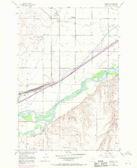
1956 Map of Mossmain
USGS Topo · Published 1970About this map
Mossmain and its surrounding rail infrastructure dominate this mid-century landscape in Yellowstone County, where the Burlington Northern lines intersect near a network of heavy agricultural industry. The area serves as a critical transportation hub, evidenced by the presence of large Stockyards and Sheep Corrals positioned along the tracks to manage livestock transport. To the south, the Clarks Fork Yellowstone River flows through a wide valley, its waters diverted through an extensive system of irrigation works including the Billings Bench Water Association Canal, Hesper Ditch, and Big Ditch.
Find a feature on this map
28 named features on this map. Tap any name to fly to it.
Don’t see what you’re looking for? This feature index may not catch every label — zoom into the map to look around manually.
Map Details
Editions of this 1956 Mossmain Map
3 editions found
Other maps of this area

1954 · Billings
USGS Topo · 1:250,000

1956 · Rimrock
USGS Topo · 1:24,000

1956 · Silesia
USGS Topo · 1:24,000

1956 · Two Pine School
USGS Topo · 1:24,000

1956 · Laurel
USGS Topo · 1:24,000

1956 · Yegen
USGS Topo · 1:24,000

1956 · Mossmain
USGS Topo · 1:24,000

1957 · Billings
USGS Topo · 1:250,000

1957 · Billings West
USGS Topo · 1:24,000

1958 · Billings
USGS Topo · 1:250,000