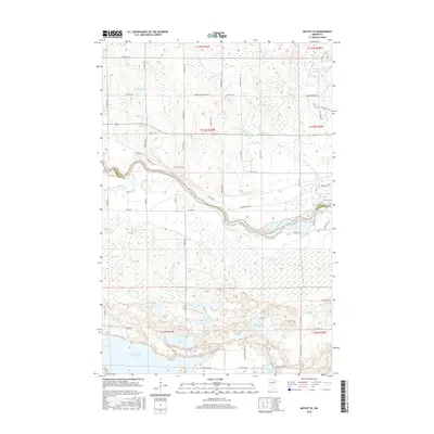
2016 Map of Motley SE
USGS Topo · Published 2016About this map
The Long Prairie River meanders across this Central Minnesota landscape, defining the boundary between Cass and Morrison counties. The region is characterized by an extensive network of glacial lakes and wetlands, including Shamineau Lake, Lake Placid, and the connected North Twin Lake and South Twin Lake. Historical transport patterns are visible through local road names like Ox Trl SW and Red River Trl SW, which hint at the earlier pioneer trails that preceded the modern grid. To the north, Sevenmile Cr drains toward the river through a mosaic of marshland and low ridges. The southern portion of the map is particularly dense with water bodies such as Stanchfield Lake and Perch Lake, surrounded by residential corridors like Cantleberry Rd and E Shamineau Dr, reflecting the area's development as a lakeside retreat.
Find a feature on this map
43 named features on this map. Tap any name to fly to it.
Don’t see what you’re looking for? This feature index may not catch every label — zoom into the map to look around manually.
Map Details
Editions of this 2016 Motley SE Map
This is the sole edition of this map. No revisions or reprints were ever made.
Other maps of this area

1916 · Pillager
USGS Topo · 1:62,500

1919 · Pillager
USGS Topo · 1:62,500

1948 · Belle Prairie
USGS Topo · 1:62,500

1948 · Cushing
USGS Topo · 1:62,500

1950 · Belle Prairie
USGS Topo · 1:62,500

1950 · Cushing
USGS Topo · 1:62,500

1953 · Brainerd
USGS Topo · 1:250,000

1954 · Pillager
USGS Topo · 1:24,000
1956 · Belle Prairie NW
USGS Topo · 1:24,000

1957 · Brainerd
USGS Topo · 1:250,000