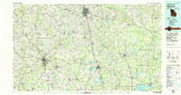
1979 Map of Moultrie
USGS Topo · Published 1980About this map
The agricultural and transit hub of Moultrie anchors this late-1970s survey, illustrating a landscape defined by its river systems and early-century rail corridors. The Georgia Northern and Seaboard Coast Line railroads provide the skeleton for numerous rural settlements, including Doerun, Norman Park, and Omega. Significant aviation infrastructure is present at the Spence Air Force Auxiliary Field and various municipal airports serving the surrounding counties.
Find a feature on this map
81 named features on this map. Tap any name to fly to it.
Don’t see what you’re looking for? This feature index may not catch every label — zoom into the map to look around manually.
Map Details
Editions of this 1979 Moultrie Map
2 editions found
Other maps of this area

1953 · Dothan
USGS Topo · 1:250,000

1953 · Waycross
USGS Topo · 1:250,000

1954 · Dothan
USGS Topo · 1:250,000

1954 · Valdosta
USGS Topo · 1:250,000

1954 · Tallahassee
USGS Topo · 1:250,000

1955 · Dothan
USGS Topo · 1:250,000

1956 · Albany East
USGS Topo · 1:24,000

1956 · Cairo
USGS Topo · 1:62,500

1956 · Baconton
USGS Topo · 1:62,500

1956 · Sylvester
USGS Topo · 1:62,500