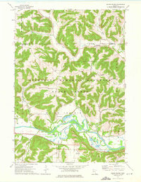
1973 Map of Mound Prairie
USGS Topo · Published 1975About this map
The Root River carves a deep valley through the driftless-style topography of Houston County, defining the agricultural and transit patterns of the early 1970s. The Chicago Milwaukee St Paul and Pacific railroad tracks parallel the river's winding course, serving the small settlement of Mound Prairie and connecting it to the larger regional network. This corridor is flanked by the expansive Minnesota Memorial Hardwood State Forest, which covers the steep bluffs and ridges that rise sharply from the valley floor.
Find a feature on this map
31 named features on this map. Tap any name to fly to it.
Don’t see what you’re looking for? This feature index may not catch every label — zoom into the map to look around manually.
Map Details
Editions of this 1973 Mound Prairie Map
This is the sole edition of this map. No revisions or reprints were ever made.
Other maps of this area

1930 · La Crescent
USGS Topo · 1:62,500

1956 · Brownsville
USGS Topo · 1:62,500

1956 · La Crescent
USGS Topo · 1:62,500

1958 · Houston
USGS Topo · 1:62,500

1958 · La Crosse
USGS Topo · 1:250,000

1961 · La Crosse
USGS Topo · 1:250,000

1965 · La Crosse
USGS Topo · 1:250,000

1965 · Sheldon
USGS Topo · 1:24,000
1973 · Pickwick
USGS Topo · 1:24,000
1973 · La Crescent
USGS Topo · 1:24,000