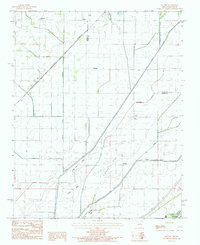
1984 Map of Mounds
USGS Topo · Published 1984About this map
The St Louis Southwestern RR cuts diagonally across this landscape, reflecting the heavy reliance on rail transport for agricultural distribution in the mid-1980s. This region, straddling the Greene and Clay county lines, is defined by a dense network of water management features including the Hurricane Ditch, Big Slough, and Mato Ditch. These engineered waterways sit alongside natural terrain like Poplar Ridge and Brushy Ridge, which provided slightly higher ground for settlements such as Mounds and Fritz. Small communities like Hopewell, Dixie, and Jay dot the northern section of the map near the Rector Airport, while the southern reaches follow the course of the St Francis River. The presence of several Cem markers and rural junctions like Slavens and Heubner offer specific points of interest for those documenting the family histories of this Northeast Arkansas bottomland.
Find a feature on this map
27 named features on this map. Tap any name to fly to it.
Don’t see what you’re looking for? This feature index may not catch every label — zoom into the map to look around manually.
Map Details
Editions of this 1984 Mounds Map
This is the sole edition of this map. No revisions or reprints were ever made.
Other maps of this area

1934 · Kennett
USGS Topo · 1:62,500

1935 · Rector
USGS Topo · 1:62,500

1940 · Marmaduke
USGS Topo · 1:62,500

1940 · Kennett
USGS Topo · 1:62,500

1940 · Piggott
USGS Topo · 1:62,500

1956 · Kennett
USGS Topo · 1:62,500

1956 · Piggott
USGS Topo · 1:62,500

1957 · Poplar Bluff
USGS Topo · 1:250,000

1958 · Marmaduke
USGS Topo · 1:62,500

1958 · Rector
USGS Topo · 1:62,500