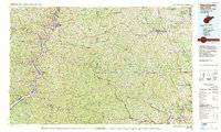
1984 Map of Moundsville
USGS Topo · Published 1984About this map
The Ohio River serves as the industrial and logistical spine for this tri-state region, carving a deep valley that separates Marshall and Wetzel counties in West Virginia from the riverfront towns of Ohio. During the mid-1980s, the river corridor was a dense network of transport, with the B & O RR and Conrail lines hugging the banks to service settlements like Moundsville and New Martinsville. To the east, the landscape shifts into the rugged Appalachian interior, where the Monongahela River provides a second major waterway for coal and commerce near Mannington and Fairview.
Find a feature on this map
221 named features on this map. Tap any name to fly to it.
Don’t see what you’re looking for? This feature index may not catch every label — zoom into the map to look around manually.
Map Details
Editions of this 1984 Moundsville Map
This is the sole edition of this map. No revisions or reprints were ever made.
Other maps of this area

1886 · St. George
USGS Topo · 1:125,000

1891 · St. George
USGS Topo · 1:125,000

1900 · Masontown
USGS Topo · 1:62,500

1901 · Amity
USGS Topo · 1:62,500

1901 · Waynesburg
USGS Topo · 1:62,500

1902 · Wheeling
USGS Topo · 1:62,500

1902 · Clarksburg
USGS Topo · 1:62,500

1902 · Brownsville
USGS Topo · 1:62,500

1902 · Fairmont
USGS Topo · 1:62,500

1902 · Morgantown
USGS Topo · 1:62,500