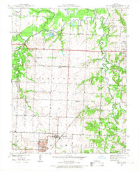
1939 Map of Moundville
USGS Topo · Published 1968About this map
Moundville serves as the central hub of this western Missouri landscape, situated just as the prairie begins its descent into the wooded drainages of the Marmaton River. The settlement pattern of the late 1930s is clearly defined by a dense network of rural schoolhouses, including Miller Sch, Nash Sch, and Carl Sch, which anchored the surrounding farming townships. The Missouri Pacific railroad cuts through the southern portion of the quadrangle, facilitating the movement of goods from small stops like Ingram and the community of Ellis. Along the river and its various sloughs, such as Bens Slough and Hattons Slough, the terrain is more varied, marked by large water bodies like Big Lake and Stultz Lake. For researchers of local family history, the map preserves the exact locations of the St Francis Convent and the Wilburn Cem, providing a precise look at the social and religious landmarks of Vernon County before mid-century modernization.
Find a feature on this map
36 named features on this map. Tap any name to fly to it.
Don’t see what you’re looking for? This feature index may not catch every label — zoom into the map to look around manually.
Map Details
Editions of this 1939 Moundville Map
3 editions found

Other maps of this area

1884 · Fort Scott
USGS Topo · 1:125,000

1886 · Nevada
USGS Topo · 1:125,000

1886 · Fort Scott
USGS Topo · 1:125,000

1893 · Fort Scott
USGS Topo · 1:125,000

1894 · Nevada
USGS Topo · 1:125,000

1933 · Camp Clark
USGS Topo · 1:24,000

1938 · Metz
USGS Topo · 1:24,000

1938 · Horton
USGS Topo · 1:24,000

1939 · Metz
USGS Topo · 1:24,000

1939 · Horton
USGS Topo · 1:24,000