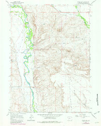
1964 Map of Mount Airy
USGS Topo · Published 1980About this map
The Green River and New Fork River converge in this high-altitude Wyoming landscape, where the meandering riverbeds contrast sharply with the surrounding arid benchlands. Ranching life is well-established along the fertile river bottoms, as evidenced by Sommers Ranch, Grubbing Hoe Ranch, and the H Bar C Ranch. The map highlights an extensive irrigation network essential for these operations, including the Green River Supply Canal, Soap Hole Ditch, and Luman Ditch. To the east, the terrain rises toward Mount Airy and The Mesa, a region dotted with water management features like Mesa Res No 1 and Desert Res No 2. A lengthy Drift Fence cuts across the high country, marking historical grazing boundaries in this portion of Sublette County.
Find a feature on this map
28 named features on this map. Tap any name to fly to it.
Don’t see what you’re looking for? This feature index may not catch every label — zoom into the map to look around manually.
Map Details
Editions of this 1964 Mount Airy Map
2 editions found
Other maps of this area

1939 · Big Piney
USGS Topo · 1:125,000

1942 · Big Piney
USGS Topo · 1:125,000

1955 · Preston
USGS Topo · 1:250,000

1955 · Lander
USGS Topo · 1:250,000

1958 · Lander
USGS Topo · 1:250,000

1958 · Preston
USGS Topo · 1:250,000

1961 · Lander
USGS Topo · 1:250,000

1962 · Preston
USGS Topo · 1:250,000

1964 · Two Buttes Reservoir
USGS Topo · 1:24,000

1964 · Mount Airy
USGS Topo · 1:24,000