
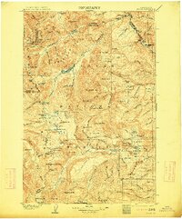
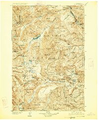
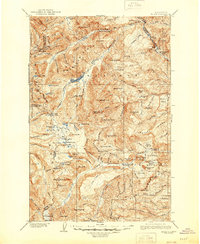
1904 Map of Mount Aix
USGS Topo · Published 1926About this map
Mount Aix stands as the central landmark in this 1904 survey of the central Cascades, revealing a high-altitude landscape defined by early resource extraction and transit corridors. The Pierce Mine near Bear Gap indicates the period's mineral prospecting, while isolated outposts like the Lake House at Bumping Lake and Russell Ranch suggest the sparse, seasonal human presence in these high valleys. This area served as a critical crossing point between Yakima, Pierce, and Lewis counties, with primitive routes traversing Carlton Pass, Cowlitz Pass, and White Pass long before modern highway development. The map also records the early infrastructure of the region's wilderness, such as the Rimrock Trail and the remote Mc Allister Meadows, capturing a moment when the high country was primarily the domain of miners, ranchers, and early forest surveyors.
Find a feature on this map
136 named features on this map. Tap any name to fly to it.
Don’t see what you’re looking for? This feature index may not catch every label — zoom into the map to look around manually.
Map Details
Editions of this 1904 Mount Aix Map
6 editions found

Other maps of this area

1897 · Mount Stuart
USGS Topo · 1:125,000

1899 · Ellensburg
USGS Topo · 1:125,000

1901 · Ellensburg
USGS Topo · 1:125,000

1901 · Snoqualmie Pass
USGS Topo · 1:125,000

1902 · Mount Aix
USGS Topo · 1:125,000

1902 · Mount Stuart
USGS Topo · 1:125,000

1903 · Snoqualmie
USGS Topo · 1:125,000

1904 · Mt Aix
USGS Topo · 1:125,000

1904 · Mount Adams
USGS Topo · 1:125,000

1907 · Mount Adams
USGS Topo · 1:125,000