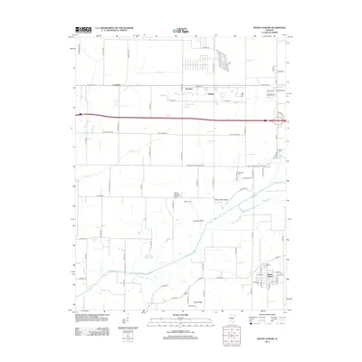
2012 Map of Mount Auburn
USGS Topo · Published 2012About this map
The Sangamon River meanders across this central Illinois landscape, carving a valley defined by distinct landforms like Hampton Bluff and Blind Horse Ridge. This area shows a settlement pattern typical of the region's agricultural roots, with the village of Mount Auburn anchoring the southeast and smaller locales such as Lanesville, Saunders, and Haynes situated along the northern transport corridor of Old Route 36. Genealogists will find a wealth of local landmarks, including several burial grounds like Riverside Cem near the river's bend and Milligan Cem further south. The topography is marked by small rises like Yellow Hammer Knob and Sand Ridge, which break the surrounding prairie. A complex network of creeks including Clear Cr, Griffith Cr, and Mosquito Cr feed into the Sangamon, influencing the historical placement of roads and homesteads.
Find a feature on this map
78 named features on this map. Tap any name to fly to it.
Don’t see what you’re looking for? This feature index may not catch every label — zoom into the map to look around manually.
Map Details
Editions of this 2012 Mount Auburn Map
This is the sole edition of this map. No revisions or reprints were ever made.
Other maps of this area

1923 · Taylorville
USGS Topo · 1:62,500

1925 · Taylorville
USGS Topo · 1:62,500

1952 · Assumption
USGS Topo · 1:62,500

1954 · Niantic
USGS Topo · 1:62,500

1954 · Mechanicsburg
USGS Topo · 1:62,500

1958 · Decatur
USGS Topo · 1:250,000

1961 · Decatur
USGS Topo · 1:250,000
1982 · Mechanicsburg
USGS Topo · 1:24,000
1982 · Stonington
USGS Topo · 1:24,000
1982 · Lake Fork
USGS Topo · 1:24,000