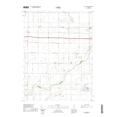
2018 Map of Mount Auburn
USGS Topo · Published 2018About this map
The Sangamon River meanders through the central Illinois prairie, marking the winding border between Sangamon County and Christian County. This 2018 survey documents the rural agricultural landscape surrounding Illiopolis and Mount Auburn, where rectilinear section lines define a grid of farm roads such as Lanesville Rd and Mechanicsburg Illiopolis Rd. Small settlements like Lanesville, Saunders, and Haynes appear as quiet junctions amidst the vast acreage of central Illinois farmland. The map reveals a high concentration of historic burial sites, including the Sangamon County Home Cem, Bethel Cem, and Milligan Cem, which are vital for genealogical research. Notable terrain variations break the flat horizon, specifically the elevations at Yellow Hammer Knob, Blind Horse Ridge, and Hampton Bluff overlooking the river valley.
Find a feature on this map
85 named features on this map. Tap any name to fly to it.
Don’t see what you’re looking for? This feature index may not catch every label — zoom into the map to look around manually.
Map Details
Editions of this 2018 Mount Auburn Map
This is the sole edition of this map. No revisions or reprints were ever made.
Other maps of this area

1923 · Taylorville
USGS Topo · 1:62,500

1925 · Taylorville
USGS Topo · 1:62,500

1952 · Assumption
USGS Topo · 1:62,500

1954 · Niantic
USGS Topo · 1:62,500

1954 · Mechanicsburg
USGS Topo · 1:62,500

1958 · Decatur
USGS Topo · 1:250,000

1961 · Decatur
USGS Topo · 1:250,000
1982 · Mechanicsburg
USGS Topo · 1:24,000
1982 · Stonington
USGS Topo · 1:24,000
1982 · Lake Fork
USGS Topo · 1:24,000