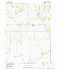
1961 Map of Mount Ayr
USGS Topo · Published 1980About this map
Mount Ayr serves as the central hub of this agricultural landscape in Jackson and Iroquois townships. The map documents an extensive network of drainage infrastructure, such as Spitler Ditch and Battleday Ditch, which reflects the historical effort to reclaim the marshy lowlands of the Kankakee outwash plain for cultivation. Genealogists will find several burial grounds across the rural sections, including North Star Cem, Kennedy Cem, and the Burr Oak Ch Cem near the eastern boundary. The southern reaches of the quadrangle are defined by the winding course of the Iroquois River and its tributary, Hickory Branch. An Old Railroad Grade running north-south through the upper sections provides a physical record of early transportation corridors that once linked these farm communities to larger regional markets.
Find a feature on this map
37 named features on this map. Tap any name to fly to it.
Don’t see what you’re looking for? This feature index may not catch every label — zoom into the map to look around manually.
Map Details
Editions of this 1961 Mount Ayr Map
2 editions found
Other maps of this area

1953 · Chicago
USGS Topo · 1:250,000

1953 · Danville
USGS Topo · 1:250,000

1955 · Danville
USGS Topo · 1:250,000

1956 · Danville
USGS Topo · 1:250,000

1957 · Chicago
USGS Topo · 1:250,000

1961 · Kentland
USGS Topo · 1:24,000

1961 · Mount Ayr
USGS Topo · 1:24,000

1961 · Morocco
USGS Topo · 1:24,000

1962 · Parr
USGS Topo · 1:24,000

1962 · Goodland
USGS Topo · 1:24,000