1948 Map of Mount Big Chief
USGS Topo · Published 1964About this map
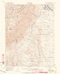
Camp Carson Military Reservation dominates the eastern landscape of this 1948 Colorado survey, showing the facility as it appeared in the post-war period. The western terrain is defined by the high elevations of the Pike National Forest, where landmarks like Mount Big Chief and St Peters Dome overlook a network of early mountain infrastructure. The map documents several recreational and educational outposts of the era, including the Broadmoor Lodge, Emerald Valley Boys Camp, and the Lytle School.
Find a feature on this map
68 named features on this map. Tap any name to fly to it.
Don’t see what you’re looking for? This feature index may not catch every label — zoom into the map to look around manually.
Map Details
Editions of this 1948 Mount Big Chief Map
2 editions found

Other maps of this area

1889 · Canon City
USGS Topo · 1:125,000

1891 · Pueblo
USGS Topo · 1:125,000

1892 · Canon City
USGS Topo · 1:125,000

1893 · Colorado Springs
USGS Topo · 1:125,000

1894 · Pikes Peak
USGS Topo · 1:125,000

1894 · Pueblo
USGS Topo · 1:125,000

1896 · Pueblo
USGS Topo · 1:125,000

1897 · Pueblo
USGS Topo · 1:125,000

1901 · Pikes Peak
USGS Topo · 1:125,000

1901 · Pikes Peak
USGS Topo · 1:62,500