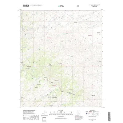
2018 Map of Mount Bigelow
USGS Topo · Published 2018About this map
Coronado National Forest defines the geography of this high-elevation landscape, where the Santa Catalina Mountains rise toward the summit of Mt Bigelow. The settlement at Soldier Camp serves as a focal point for the area, situated near Bear Wallow and the high ridges of Oracle Ridge. This environment is characterized by dramatic elevation changes, documented through features like Palisade Rock and Lombar Hill. Water sources are critical in this arid montane terrain, marked by numerous tanks and springs such as Ventana Tank, Juanito Spring, and Eagle Spring. The inclusion of the Arizona National Scenic Trail highlights the region's importance for transit and exploration along the crest. A network of canyons, including Edgar Canyon and Diablo Canyon, drains the massif, illustrating the complex erosional patterns that have shaped these peaks.
Find a feature on this map
84 named features on this map. Tap any name to fly to it.
Don’t see what you’re looking for? This feature index may not catch every label — zoom into the map to look around manually.
Map Details
Editions of this 2018 Mount Bigelow Map
This is the sole edition of this map. No revisions or reprints were ever made.
Other maps of this area

1904 · Tucson
USGS Topo · 1:125,000

1905 · Tucson
USGS Topo · 1:125,000

1911 · Winkelman
USGS Topo · 1:125,000

1913 · Winkelman
USGS Topo · 1:125,000

1948 · Mammoth
USGS Topo · 1:62,500

1948 · Campo Bonito
USGS Topo · 1:24,000

1948 · Peppersauce Wash
USGS Topo · 1:24,000

1949 · Campo Bonito
USGS Topo · 1:24,000
1949 · Peppersauce Wash
USGS Topo · 1:24,000
1951 · Mammoth
USGS Topo · 1:62,500