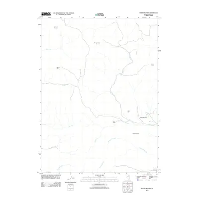
2012 Map of Mount Blitzen
USGS Topo · Published 2012About this map
Mount Blitzen and Battle Mountain dominate this corner of Elko County, defining a landscape of high summits and deep drainages. In this 2012 survey, the terrain is characterized by a series of significant peaks, including Mount Neva and McCann Creek Mountain, which overlook the complex network of mountain streams. The watershed is clearly defined by several perennial and intermittent flows such as Toe Jam Creek, Rock Creek, and McCann Creek. The map provides a look at the natural features that have long influenced cattle ranching and mineral exploration in this part of northern Nevada. Lowland features like Berry Basin and Pleasant Valley Creek provide a contrast to the surrounding elevations of Dry Creek Mountain and Castile Mountain. This specific representation of the Great Basin geography captures the topographical relationship between these prominent landmarks before modern development could further alter the remote character of the region.
Find a feature on this map
18 named features on this map. Tap any name to fly to it.
Don’t see what you’re looking for? This feature index may not catch every label — zoom into the map to look around manually.
Map Details
Editions of this 2012 Mount Blitzen Map
This is the sole edition of this map. No revisions or reprints were ever made.
Other maps of this area

1955 · McDermitt
USGS Topo · 1:250,000

1956 · Tuscarora
USGS Topo · 1:62,500

1956 · Mt. Blitzen
USGS Topo · 1:62,500

1959 · McDermitt
USGS Topo · 1:250,000

1970 · Sugarloaf Butte
USGS Topo · 1:24,000

1970 · Lake Mountain
USGS Topo · 1:24,000
1970 · China Camp
USGS Topo · 1:24,000
1972 · Lake Mountain
USGS Topo · 1:24,000

1982 · Tuscarora
USGS Topo · 1:100,000
1987 · Cottonwood Peak
USGS Topo · 1:24,000