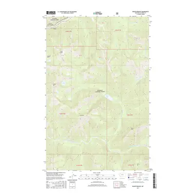
2017 Map of Mount Bradley
USGS Topo · Published 2017About this map
Glacier National Park and Flathead National Forest meet in this high-altitude landscape defined by the drainage systems of the Middle Fork Flathead River. The northern portion of the map is dominated by the narrow passage of John F Stevens Canyon and the historic transit point at Theodore Roosevelt Pass. Numerous mountain lakes, including Moose Lake and Giefer Lake, are tucked into the drainages of Moose Creek and Giefer Creek, illustrating the complex glacial hydrology of the region. Significant vertical relief is captured between prominent peaks such as Mt Bradley and Forster Mtn, providing a clear record of the backcountry terrain as it was managed in the early twenty-first century. This survey documents the intersection of protected federal lands and the remote watersheds that feed into the Flathead River system.
Find a feature on this map
35 named features on this map. Tap any name to fly to it.
Don’t see what you’re looking for? This feature index may not catch every label — zoom into the map to look around manually.
Map Details
Editions of this 2017 Mount Bradley Map
This is the sole edition of this map. No revisions or reprints were ever made.
Other maps of this area

1913 · Marias Pass
USGS Topo · 1:125,000

1914 · Nyack
USGS Topo · 1:125,000

1958 · Red Plume Mountain
USGS Topo · 1:24,000

1958 · Capitol Mountain
USGS Topo · 1:24,000

1958 · Circus Peak
USGS Topo · 1:24,000

1958 · Nimrod
USGS Topo · 1:24,000

1958 · Mount Bradley
USGS Topo · 1:24,000

1958 · Horseshoe Peak
USGS Topo · 1:24,000

1960 · Cut Bank
USGS Topo · 1:250,000

1963 · Cut Bank
USGS Topo · 1:250,000