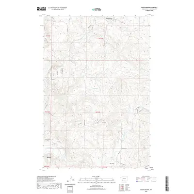
2020 Map of Mount Brynion
USGS Topo · Published 2020About this map
The Kelso area and the adjacent timberlands of Cowlitz County are defined by a complex network of industrial and rural corridors as they appeared in 2020. This landscape is anchored by Mt Brynion and dominated by the drainage basins of the Coweeman River and the S Fork Ostrander Cr. The map reveals the logistical infrastructure of the Pacific Northwest's forestry heritage, featuring the Weyerhaeuser Rd and Logging 1600 Rd which penetrate the high country toward Clc Junction and the small settlement at Headquarters. In the lower elevations, rural life is marked by the presence of Rose Valley and the winding course of Goble Cr. These detailed transport patterns, from Hamilton Heights Rd to the various loops and spurs like Nesbit Loop Rd, illustrate the intersection of local residential development and the region's enduring timber-based economy.
Find a feature on this map
47 named features on this map. Tap any name to fly to it.
Don’t see what you’re looking for? This feature index may not catch every label — zoom into the map to look around manually.
Map Details
Editions of this 2020 Mount Brynion Map
This is the sole edition of this map. No revisions or reprints were ever made.
Other maps of this area

1921 · Kalama
USGS Topo · 1:62,500

1941 · Olequa
USGS Topo · 1:62,500

1942 · Toutle
USGS Topo · 1:62,500

1943 · Pigeon Springs
USGS Topo · 1:62,500

1953 · Hoquiam
USGS Topo · 1:250,000

1953 · Toutle
USGS Topo · 1:62,500

1953 · Castle Rock
USGS Topo · 1:62,500

1953 · Mt. Brynion
USGS Topo · 1:24,000

1953 · Pigeon Springs
USGS Topo · 1:62,500

1953 · Rainier
USGS Topo · 1:24,000