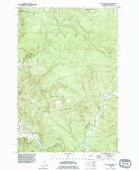
1990 Map of Mount Brynion
USGS Topo · Published 1995About this map
Mt Brynion dominates the central topography of this 1990 revision, which documents the industrial and natural landscape of eastern Cowlitz County. The Coweeman River winds through the southern reaches of the map, joined by Goble Creek and passing a Gaging Sta near the Kelso Corporate Boundary. This period of land management is clearly visible through the extensive network of Logging Roads and the Headquarters located in the northern hills.
Find a feature on this map
19 named features on this map. Tap any name to fly to it.
Don’t see what you’re looking for? This feature index may not catch every label — zoom into the map to look around manually.
Map Details
Editions of this 1990 Mount Brynion Map
This is the sole edition of this map. No revisions or reprints were ever made.
Other maps of this area

1921 · Kalama
USGS Topo · 1:62,500

1941 · Olequa
USGS Topo · 1:62,500

1942 · Toutle
USGS Topo · 1:62,500

1943 · Pigeon Springs
USGS Topo · 1:62,500

1953 · Hoquiam
USGS Topo · 1:250,000

1953 · Toutle
USGS Topo · 1:62,500

1953 · Castle Rock
USGS Topo · 1:62,500

1953 · Mt. Brynion
USGS Topo · 1:24,000

1953 · Pigeon Springs
USGS Topo · 1:62,500

1953 · Rainier
USGS Topo · 1:24,000