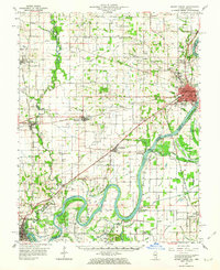
1959 Map of Mount Carmel
USGS Topo · Published 1963About this map
The Wabash River serves as the focal point for this mid-century look at the Illinois-Indiana border, where the river's deep meanders like Peankishaw Bend and Schuh Bend create a complex boundary landscape of islands and bayous. In Mount Carmel, the regional hub, a concentrated grid of streets is surrounded by mid-century infrastructure including a Sewage Disposal plant and a Radio Tower (WVMC). Further south, the river is flanked by an extensive network of drainage projects such as the Rochester and Mc Leary Ditch and Higginbotham Ditch, which converted the bottomlands into productive territory.
Find a feature on this map
102 named features on this map. Tap any name to fly to it.
Don’t see what you’re looking for? This feature index may not catch every label — zoom into the map to look around manually.
Map Details
Editions of this 1959 Mount Carmel Map
2 editions found
Other maps of this area

1901 · Princeton
USGS Topo · 1:62,500

1901 · Haubstadt
USGS Topo · 1:62,500

1903 · Haubstadt
USGS Topo · 1:62,500

1903 · New Harmony
USGS Topo · 1:62,500

1903 · Princeton
USGS Topo · 1:62,500

1903 · Patoka
USGS Topo · 1:125,000

1904 · Mount Carmel
USGS Topo · 1:62,500

1911 · Sumner
USGS Topo · 1:62,500

1913 · Sumner
USGS Topo · 1:62,500

1915 · Vincennes
USGS Topo · 1:62,500