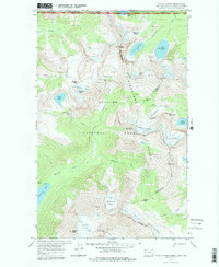
1968 Map of Mount Carter
USGS Topo · Published 1979About this map
The Continental Divide carves a path through the Livingstone Range in this 1968 field-checked record of the high-altitude landscape where Glacier National Park meets Waterton Lakes National Park. This survey documents a complex system of ice and water, including the Boulder Glacier, Weasel Collar Glacier, and the Carter Glaciers flanking Mount Carter. The map captures the international boundary as it runs between the United States and Canada, specifically where Montana meets British Columbia and Alberta. Human presence is represented only by a network of primitive corridors, including the Trail through Boulder Pass and the notable Hole-in-the-Wall campsite, illustrating the remote character of the northern Rockies before modern infrastructure altered backcountry access. Natural landmarks such as The Guardhouse, The Sentinel, and the sheer drops of Thunderbird Falls define this high-relief terrain.
Find a feature on this map
46 named features on this map. Tap any name to fly to it.
Don’t see what you’re looking for? This feature index may not catch every label — zoom into the map to look around manually.
Map Details
Editions of this 1968 Mount Carter Map
3 editions found
Other maps of this area

1904 · Chief Mountain
USGS Topo · 1:125,000

1906 · Kintla Lakes
USGS Topo · 1:125,000

1938 · Chief Mountain
USGS Topo · 1:125,000

1938 · Kintla Lakes
USGS Topo · 1:125,000

1957 · Kalispell
USGS Topo · 1:250,000

1960 · Kalispell
USGS Topo · 1:250,000

1960 · Cut Bank
USGS Topo · 1:250,000

1961 · Kalispell
USGS Topo · 1:250,000

1963 · Cut Bank
USGS Topo · 1:250,000

1964 · Cut Bank
USGS Topo · 1:250,000