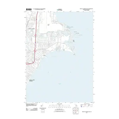
2011 Map of Mount Clemens East
USGS Topo · Published 2011About this map
Lake Saint Clair dominates the southern half of this coastal survey, where the Clinton River meanders eastward to meet the freshwater delta at Anchor Bay. The landscape is defined by its complex shoreline, characterized by numerous points and bays such as L'Anse Creuse Bay, Campau Bay, and the prominent Point Huron. This area reflects a highly developed suburban and maritime interface, with dense residential street grids in Mount Clemens and Saint Clair Shores pushing right to the water's edge. The presence of Selfridge ANGB Airport to the north underscores the region's strategic military importance. Inland, the map reveals a network of engineered waterways like the Peltier Drain and Tebo Drain, which manage the low-lying terrain. From the small-craft facilities at Ensign Access Point to the residential enclaves of Lakeside and Saint Clair Haven, the map documents a community deeply integrated with the Great Lakes ecosystem.
Find a feature on this map
104 named features on this map. Tap any name to fly to it.
Don’t see what you’re looking for? This feature index may not catch every label — zoom into the map to look around manually.
Map Details
Editions of this 2011 Mount Clemens East Map
This is the sole edition of this map. No revisions or reprints were ever made.
Other maps of this area

1905 · Grosse Pointe
USGS Topo · 1:62,500

1912 · Mt Clemens
USGS Topo · 1:62,500

1914 · Algonac
USGS Topo · 1:62,500

1918 · Grosse Pointe
USGS Topo · 1:62,500

1929 · Mt Clemens
USGS Topo · 1:62,500

1936 · New Haven
USGS Topo · 1:31,680

1936 · Waldenburg
USGS Topo · 1:31,680

1936 · Selfridge Field
USGS Topo · 1:31,680

1936 · New Baltimore
USGS Topo · 1:31,680
1936 · Grosse Pointe
USGS Topo · 1:31,680
Featured Places
- Clinton Township, MI
- Saint Clair Shores, MI
- Harrison Township, MI
- Mount Clemens, MI
- Saint Clair Haven, Harrison Township