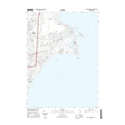
2017 Map of Mount Clemens East
USGS Topo · Published 2017About this map
Selfridge Air National Guard Base dominates the northern shoreline of L'anse Creuse Bay, a significant military presence at the heart of this coastal Macomb County landscape. The map illustrates the complex drainage systems of the region, including the Clinton River and the man-made Clinton River Spillway, which are essential to the hydrologic management of the lowland areas near Lake Saint Clair. The residential patterns of Mount Clemens and Harrison are well-defined, showing the dense grid of streets and the transition from urban centers to waterfront communities like Saint Clair Haven and Lakeside. For genealogists, the Tucker Family Cem provides a specific point of local heritage, while features such as Sand Point and Grass Island define the shifting interface between the land and the waters of Anchor Bay.
Find a feature on this map
161 named features on this map. Tap any name to fly to it.
Don’t see what you’re looking for? This feature index may not catch every label — zoom into the map to look around manually.
Map Details
Editions of this 2017 Mount Clemens East Map
This is the sole edition of this map. No revisions or reprints were ever made.
Other maps of this area

1905 · Grosse Pointe
USGS Topo · 1:62,500

1912 · Mt Clemens
USGS Topo · 1:62,500

1914 · Algonac
USGS Topo · 1:62,500

1918 · Grosse Pointe
USGS Topo · 1:62,500

1929 · Mt Clemens
USGS Topo · 1:62,500

1936 · New Haven
USGS Topo · 1:31,680

1936 · Waldenburg
USGS Topo · 1:31,680

1936 · Selfridge Field
USGS Topo · 1:31,680

1936 · New Baltimore
USGS Topo · 1:31,680
1936 · Grosse Pointe
USGS Topo · 1:31,680
Featured Places
- Clinton Township, MI
- Saint Clair Shores, MI
- Harrison Township, MI
- Mount Clemens, MI
- Saint Clair Haven, Harrison Township