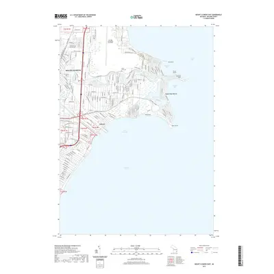
2019 Map of Mount Clemens East
USGS Topo · Published 2019About this map
Mount Clemens and the surrounding shoreline of Lake Saint Clair are defined by an intricate network of waterways and maritime residential developments. The Clinton River flows eastward through the heart of the region, flanked by its namesake spillway, eventually meeting the lake at Sunshine Point. This modern survey reveals the high density of canal-front neighborhoods and marinas that characterize communities like Saint Clair Haven and Lakeside. To the north, the massive footprint of Selfridge Air National Guard Base occupies the peninsula between the river and Anchor Bay, serving as a major regional landmark. Historic traces remain visible amidst the suburban expansion, notably the Tucker Family Cem situated near the riverbanks. The map documents a landscape deeply shaped by its proximity to the Great Lakes system, where every point of land, from Sand Point to Point Huron, is utilized for its access to the surrounding bays.
Find a feature on this map
143 named features on this map. Tap any name to fly to it.
Don’t see what you’re looking for? This feature index may not catch every label — zoom into the map to look around manually.
Map Details
Editions of this 2019 Mount Clemens East Map
This is the sole edition of this map. No revisions or reprints were ever made.
Other maps of this area

1905 · Grosse Pointe
USGS Topo · 1:62,500

1912 · Mt Clemens
USGS Topo · 1:62,500

1914 · Algonac
USGS Topo · 1:62,500

1918 · Grosse Pointe
USGS Topo · 1:62,500

1929 · Mt Clemens
USGS Topo · 1:62,500

1936 · New Haven
USGS Topo · 1:31,680

1936 · Waldenburg
USGS Topo · 1:31,680

1936 · Selfridge Field
USGS Topo · 1:31,680

1936 · New Baltimore
USGS Topo · 1:31,680
1936 · Grosse Pointe
USGS Topo · 1:31,680
Featured Places
- Clinton Township, MI
- Saint Clair Shores, MI
- Harrison Township, MI
- Mount Clemens, MI
- Saint Clair Haven, Harrison Township