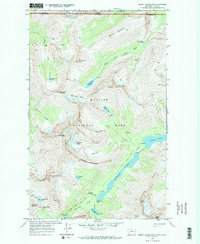
1968 Map of Mount Cleveland
USGS Topo · Published 1971About this map
The high peaks of Glacier National Park and Waterton Lakes National Park meet at the Canada United States border in this 1968 study. The landscape is defined by massive alpine features, including Mount Cleveland and Whitecrow Mountain, which tower over significant ice bodies like the Whitecrow Glacier and Miche Wabun Glacier. The drainage patterns are intricate, with the North Fork Belly River and Mokowanis River feeding a series of glacial lakes such as Glenns Lake and Cosley Lake. Hikers and researchers can trace the historic route of the Stoney Indian Pass and locate remote landmarks like the Mokowanis Shelter Cabin near the shoreline of Mokowanis Lake. The map details numerous water features, from the Mokowanis Cascade to White Quiver Falls, illustrating the high-altitude hydrology of the Alberta Montana border region.
Find a feature on this map
44 named features on this map. Tap any name to fly to it.
Don’t see what you’re looking for? This feature index may not catch every label — zoom into the map to look around manually.
Map Details
Editions of this 1968 Mount Cleveland Map
2 editions found
Other maps of this area

1904 · Chief Mountain
USGS Topo · 1:125,000

1938 · Chief Mountain
USGS Topo · 1:125,000

1960 · Cut Bank
USGS Topo · 1:250,000

1963 · Cut Bank
USGS Topo · 1:250,000

1964 · Cut Bank
USGS Topo · 1:250,000

1968 · Ahern Pass
USGS Topo · 1:24,000

1968 · Gable Mountain
USGS Topo · 1:24,000
1968 · Porcupine Ridge
USGS Topo · 1:24,000
1968 · Mount Cleveland
USGS Topo · 1:24,000
1968 · Mount Geduhn
USGS Topo · 1:24,000