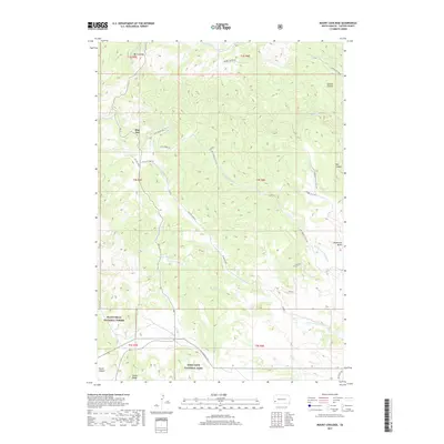
2017 Map of Mount Coolidge
USGS Topo · Published 2017About this map
Black Hills National Forest and Wind Cave National Park converge in this high-altitude landscape of Custer County, dominated by the peak of Mt Coolidge. The terrain is defined by a series of significant drainages, including French Cr and the various branches of N Fork Lame Johnny Cr, which carve through deep formations like Gordon Canyon and Red Canyon. The small settlement of Blue Bell serves as a central point for a network of forest and park roads such as Wildlife Loop Rd and Lame Johnny Rd. The southern portion of the sheet highlights the transition into the protected cave lands, featuring landmarks like Rankin Ridge and Highland Cr. These topographic details illustrate the complex boundary between managed forest and national park land, showing the essential infrastructure used for wildfire management and conservation access.
Find a feature on this map
37 named features on this map. Tap any name to fly to it.
Don’t see what you’re looking for? This feature index may not catch every label — zoom into the map to look around manually.
Map Details
Editions of this 2017 Mount Coolidge Map
This is the sole edition of this map. No revisions or reprints were ever made.
Other maps of this area

1894 · Hermosa
USGS Topo · 1:125,000

1896 · Harney Peak
USGS Topo · 1:125,000

1901 · Hermosa
USGS Topo · 1:125,000

1901 · Harney Peak
USGS Topo · 1:125,000

1954 · Iron Mountain
USGS Topo · 1:24,000

1954 · Custer
USGS Topo · 1:24,000

1954 · Hayward
USGS Topo · 1:24,000

1954 · Mount Rushmore
USGS Topo · 1:62,500

1955 · Mt. Coolidge
USGS Topo · 1:24,000
1955 · Cicero Peak
USGS Topo · 1:24,000