1904 Map of Mount Desert
USGS Topo · Published 1918About this map
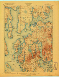
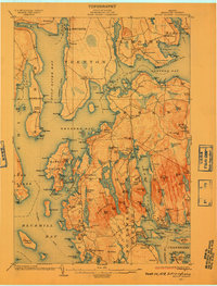
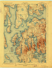
Mount Desert Island dominates this coastal survey, revealing the intricate geography of the Maine shoreline before the mid-century expansion of Acadia. The map documents early-century land use, from the granite extraction at Hall Quarry to the maritime infrastructure of the U.S. Coaling Station on Eastern Bay. While much of the island's interior is preserved within the Lafayette National Monument, the surrounding coastal fringes are dotted with established maritime villages. The established Steamboat Route serves as a reminder of the era's primary transportation network, connecting points like Southwest Harbor and Marlboro to the mainland. The landscape is defined by its massive glacial ponds, including Long Pond and Eagle Lake, which sit between high peaks like Western Mountain. This 1904 edition, updated to 1918, provides a clear view of the area's transition from an industrial and fishing economy toward its future as a premier destination.
Find a feature on this map
126 named features on this map. Tap any name to fly to it.
Don’t see what you’re looking for? This feature index may not catch every label — zoom into the map to look around manually.
Map Details
Editions of this 1904 Mount Desert Map
5 editions found

Other maps of this area

1900 · Orland
USGS Topo · 1:62,500

1904 · Deer Isle
USGS Topo · 1:62,500

1904 · Mount Desert
USGS Topo · 1:62,500

1904 · Swan Island
USGS Topo · 1:62,500

1904 · Bar Harbor
USGS Topo · 1:62,500

1904 · Bluehill
USGS Topo · 1:62,500

1905 · Penobscot Bay
USGS Topo · 1:125,000

1911 · Ellsworth
USGS Topo · 1:62,500

1930 · Tunk Lake
USGS Topo · 1:48,000

1932 · Tunk Lake
USGS Topo · 1:62,500